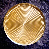


H2O Stint Map
2004 – Stainless steel, copper, concrete, shells/grit from the site – 5.5m x 1.2 m x 1m
H2O Stint Map takes its name and shape from two of the site’s most remarkable features: the water and the wildlife. Researching this work came up with a direct link between the Red necked Stint and the shape of water.
The water molecule is too small to be seen even through the most powerful microscope, but science agrees on its shape and makeup. It is two hydrogen atoms joined to an oxygen atom at an angle of 105 degrees. Migratory birds, including red-necked stints, fly from this wetland and travel 105 degrees around the globe northwards to the Siberian wetlands and back every year. Just like tiny subatomic particles, these birds trace out the shape of water on to the surface of the world.
H2O Stint Map uses the water molecule shape with an image of the globe superimposed into the hydrogen atoms on top of a “Fibonacci spiral” to draw a link between the water and the flight paths of these amazing birds.